Stratospheric Aerosol Extinction Profile Retrieval from SCIAMACHY Limb Measurements
[YANG Jing-Mei , ZONG Xue-Mei]
, ZONG Xue-Mei]
|
|


Stratospheric aerosol extinction profiles are retrieved from Scanning Imaging Absorption Spectrometer for Atmospheric Cartography (SCIAMACHY) limb scatter measurements. In the process of retrieval, the SCIATRAN radiative transfer model is used to simulate the limb scattering radiation received by the SCIAMACHY instrument, and an optimal estimation algorithm is used to calculate the aerosol extinction profiles. Sensitivity analyses are performed to investigate the impact of the surface albedo on the accuracy of the retrieved aerosol extinction profiles in the northern midlatitudes. It is found that the errors resulting from the bias of the assumed surface albedo in the retrieval are generally below 6%. The retrieved SCIAMACHY aerosol extinction profiles are compared with corresponding Stratospheric Aerosol and Gas Experiment (SAGE) II measurements, and the results indicate that for the zonal mean profiles, the SCIAMACHY retrievals show good agreement with SAGE II measurements, with the absolute differences being less than 2.3×10⁻⁵ km-1 from 14-25 km, and less than 5.9×10⁻⁶ km-1 from 25-35 km; and the relative differences being within 20% over the latitude range of 14-35 km.
Stratospheric aerosols play an important role in the physics and chemistry of the atmosphere (e.g., Hofmann and Solomon, 1989; McCormick et al., 1995; Hu and Shi, 1998). Therefore, long-term measurement of their distributions is necessary for a better understanding and modeling of stratospheric processes. Before the mid-2000s, satellite aerosol profile measurements were mainly carried out by instruments using the solar occultation technique, and such instruments include the Stratospheric Aerosol Measurement (SAM) ( Russell et al., 1981), the Stratospheric Aerosol and Gas Experiment (SAGE) ( McCormick, 1987), and the Halogen Occultation Experiment (HALOE) Russell III et al., 1993). This technique provides aerosol extinction profiles with high accuracy and high vertical resolution, but suffers from poor geographical coverage. Since SAGE II and III stopped working in 2005/2006, no instrument with this technique provides continuous aerosol profile measurements in the stratosphere. The new generation of spaceborne instruments perform limb measurements of the scattered solar radiation in the Earth's atmosphere. This category of instruments mainly includes the Optical Spectrograph and Infrared Imager System (OSIRIS) ( Llewellyn et al., 2004), as well as the Scanning Imaging Absorption Spectrometer for Atmospheric Cartography (SCIAMACHY) Bovensman et al., 1999). These limb observations provide a vast amount of information on atmospheric trace gases and aerosols, and can be used to retrieve their vertical profiles. Owing to the sophisticated nature of radiative transfer simulations and the associated retrieval calculation, no limb aerosol profile products are currently available. However, if all these limb measurements were to be employed in establishing reliable aerosol profile datasets, it would help in terms of the current scarcity of stratospheric aerosol data and would certainly benefit related studies.
As part of the efforts to retrieve aerosol profiles from satellite limb observations, Bourassa et al. (2007) retrieved stratospheric aerosol number densities from the OSIRIS limb scatter measurements by utilizing the one-dimensional multiplicative algebraic reconstruction technique (MART) inversion method. Taha et al. (2011) retrieved aerosol extinction profiles from SCIAMACHY limb observations by employing the Ozone Mapper and Profiler Suite/Limp Profiler (OMPS/LP) algorithm. Ovigneur et al. (2011) presented an approach to retrieve stratospheric aerosol number densities from SCIAMACHY limb measurements in the spectral range of the O2A absorption band.
In this paper, we attempt to use another method to retrieve the aerosol extinction profiles from the limb measurements of the SCIAMACHY satellite spectrometer. We employ the SCIATRAN radiative transfer model ( Rozanov et al., 2002, 2005) for the calculation of limb scatter spectra and use the optimal estimation method proposed by Rodgers (2000) for retrieval.
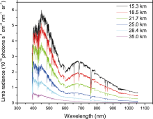
SCIAMACHY is a passive imaging spectrometer launched on board the European Environmental Satellite (ENVISAT-1) in March 2002. It comprises eight spectral channels and covers a wide spectral range from 240 to 2380 nm. SCIAMACHY has three viewing modes: nadir, sun/moon occultation, and limb. In the limb mode, horizontal scans of the Earth's atmosphere are made from 3 km below the horizon to about 100 km, with 3.3 km vertical intervals. The vertical field of view in limb observation mode is about 2.6 km, and the horizontal field of view is 110 km at the tangent point. Figure 1 shows sample SCIAMACHY limb scatter spectra (channels 3, 4, and 5) on 22 January 2004 when the tangent point passed over Taklimakan Desert in western China (39.6°N, 81.1°E). In this study, we use the SCIAMACHY level 1 version 7.04 limb observation data for retrieval.
 | Figure 1 Scanning Imaging Absorption Spectrometer for Atmospheric Cartography (SCIAMACHY) limb radiance spectra at 15.3, 18.5, 21.7, 25.0, 28.4, and 35.0 km tangent height on 22 January 2004, when the tangent point passed over Taklimakan Desert in western China (39.6°N, 81.1°E). |
The basic equation to be solved for the retrieval is a nonlinear inverse problem ( Rodgers, 2000):

where y is the measurement vector, i.e., the measured limb spectrum; F is the forward model accounting for the physics of the measurement; x is the state vector, which contains the aerosol extinction profile to be retrieved; b is the vector of forward model parameters (e.g., a priori aerosol profile); and e y represents measurement errors of all kinds.
In order to reduce the sensitivity to the assumed surface albedo and to render an absolute calibration of the instrument unnecessary, the measurement vector is defined as the normalized radiance at a reference tangent height:
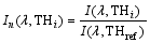
where I ( λ, TH i) indicates the limb radiance at wavelength λ and tangent height TH i, and THref is the reference tangent height. In this study, the reference tangent height is chosen at 36 km, where the value of aerosol extinction is small and negligible. The wavelength for the retrieval is chosen at 750 nm, since at this wavelength aerosol is known to be sensitive to the limb scatter signal, and it corresponds to weak gaseous absorption and is away from straylight contaminations ( Taha et al., 2011).
The retrieval algorithm used in this study is based on the optimal estimation method described by Rodgers (2000). For this retrieval, the a priori aerosol extinction profile is constructed by averaging the zonal monthly mean SAGE II aerosol extinction profiles for the period 1998-2004. The simulated limb radiance spectra and appropriate weighting functions are calculated with the SCIATRAN radiative transfer model ( Rozanov et al., 2002, 2005). In the process of calculation, the stratospheric background aerosol conditions are assumed, since there have been no major volcanic eruptions following the Pinatubo eruption in June 1991. The surface albedo used in the retrieval is assumed to have a constant value of 0.3.
In the process of retrieval, we use the average surface albedo value of 0.3 in our calculation. As an unknown parameter, the surface albedo varies across the surface because of different geological and environmental features. In this section we perform sensitivity analyses to investigate the impact of the bias in the assumed surface albedo on the accuracy of the aerosol extinction retrieval. Table 1 gives the relative errors of the retrieved aerosol extinctions for the latitude of 40°N when the true surface albedo values are 0.1, 0.2, 0.4, and 0.5, while the assumed surface albedo is 0.3 in the retrieval. It can be seen from Table 1 that when the assumed surface albedo is higher (lower) than the actual value, it leads to a low (high) bias in the retrieved aerosol extinctions. The errors caused by the bias of the assumed surface albedo in the retrieval are generally below 6% in the northern midlatitudes.
| Table 1 Relative errors (err) of the retrieved aerosol extinctions by using the assumed surface albedo A = 0.3 in the retrieval when the actual surface albedo values are A = 0.1, 0.2, 0.4, and 0.5. |
3.2 Comparisons with SAGE II measurements
The retrieved aerosol extinction profiles are compared with the corresponding SAGE II (version 6.2) measurements. Detailed validation studies of SAGE II aerosol products have been performed previously in many studies (e.g., Russell and McCormick, 1989; Hervig and Deshler, 2002), and the results have demonstrated that SAGE II aerosol extinction profiles are reliable and accurate, particularly in the 1020 nm and 525 nm channels.
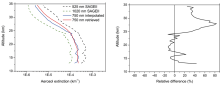
Figure 2 shows a comparison of an aerosol extinction profile retrieved from the SCIAMACHY limb measurements (39.6°N, 81.1°E) at 0450 UTC 22 January 2004 and the profile measured by SAGE II (38.4°N, 95.2°E) on the same day at 1044 UTC. The SAGE II 750 nm extinction profile was calculated by interpolating from measurements at 525 nm and 1020 nm. As seen from Fig. 2, the retrieved SCIAMACHY aerosol extinction profile matches the overall shape of the SAGE II measurements. The absolute differences between the retrieved and SAGE II measured aerosol extinctions are less than 3.8×10⁻⁵ km-1 from 14-25 km, and less than 1.9×10⁻⁵ km-1 from 25-35 km. The relative differences between SCIAMACHY and SAGE II are generally within 20% at the altitude range of 14-25 km; but at some altitude levels above 25 km, the relative differences exhibit very high values. The larger relative differences can be explained by the differences in time and geographic location of the two measurements, and the effects of uncertain parameters (i.e., surface albedo) used in the retrieval.
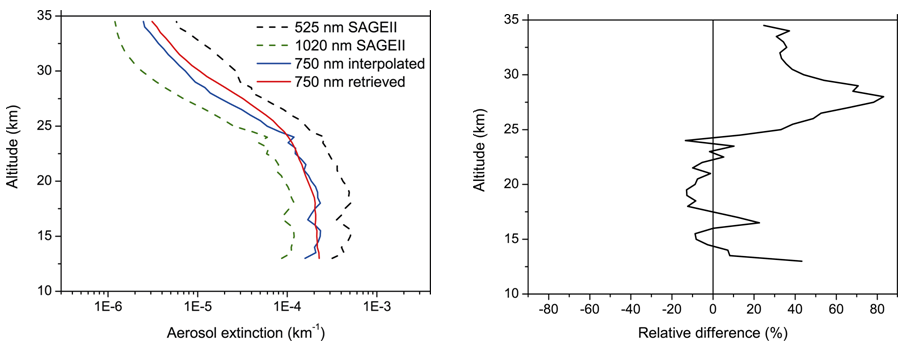 | Figure 2 SCIAMACHY aerosol extinction profile (39.6°N, 81.1°E) at 0450 UTC 22 January 2004 compared to Stratospheric Aerosol and Gas Experiment (SAGE) II measurements (38.4°N, 95.2°E) on the same day at 1044 UTC. The 750 nm SAGE II profile is calculated by interpolating from measurements at 525 nm and 1020 nm (left panel). The right panel is the relative difference of the retrieved SCIAMACHY aerosol extinctions in comparison to SAGE II measurements. Relative difference = (SCIAMACHY-SAHE II) / SAGE II × 100%. |
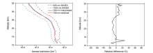
Figure 3 shows a comparison between the zonal mean aerosol extinction profile (averaged over 16 individual measurements) from the SCIAMACHY retrieval and the zonal mean profile calculated from 16 corresponding SAGE II measurements. All the observations were performed within a 35°N-40°N latitude band on 21 and 22 January 2004. The corresponding SAGE II measurements were chosen to be within 12 hours, 4° of latitude, and 20° of longitude of the SCIAMACHY observations. It can be seen from Fig. 3 that the retrieved SCIAMACHY aerosol extinction profile conforms well with the SAGE II measurements, with the absolute differences being less than 2.3×10⁻⁵ km-1from 14-25 km, and less than 5.9×10⁻⁶ km-1 from 25-35 km; and the relative differences of the retrieval are within 20% over the altitude range of 14-35 km.
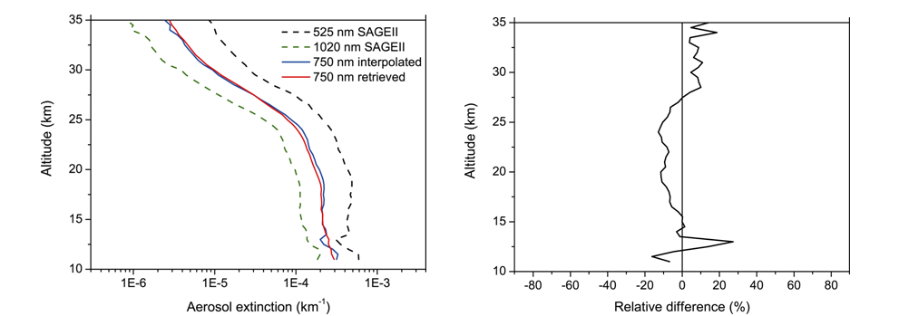 | Figure 3 The zonal mean SCIAMACHY aerosol extinction profile compared to the zonal mean SAGE II measurements (average values of 16 individual measurements). The observations are within the 35°N-40°N latitude band, and were performed on 21 and 22 January 2004 (left panel). The right panel is the relative difference of the zonal mean retrieved SCIAMACHY aerosol extinctions in comparison to SAGE II measurements. |
In this study, the aerosol extinction profiles were retrieved from SCIAMACHY limb observations. Sensitivity analyses were performed to investigate the impact of the surface albedo on the accuracy of the aerosol extinction retrieval. We found that the relative errors resulting from the bias of the assumed surface albedo in the retrieval are generally below 6% in the northern midlatitudes. Comparison of the SCIAMACHY limb retrievals with SAGE II measurements showed that, for individual measurements, the relative differences may have larger values at some altitude levels above 25 km. However, for the corresponding zonal mean profiles, SCIAMACHY retrievals show good agreement with SAGE II measurements, with the relative differences being within 20% over the altitude range of 14-35 km. Based on the present reported study, we can conclude that our retrievals are reliable and accurate.
| 1 |
|
| 2 |
|
| 3 |
|
| 4 |
|
| 5 |
|
| 6 |
|
| 7 |
|
| 8 |
|
| 9 |
|
| 10 |
|
| 11 |
|
| 12 |
|
| 13 |
|
| 14 |
|
| 15 |
|
| 16 |
|
| 17 |
|