Tides and Wind-Driven Circulation in the Tropical and Southern Atlantic Ocean: The BRAZCOAST System
[Ricardo de CAMARGO1  , Joseph HARARI
2 ]
, Joseph HARARI|
|


The Brazilian coast is characterized by different tidal regimes and distinct meteorological influences. The northern part has larger tidal amplitudes and is permanently affected by trade winds and tropical disturbances; the southern portion has smaller tidal amplitudes and is frequently influenced by extratropical cyclone activity. Besides these aspects, many features regarding current structure and behavior are also present, such as the equatorial system of currents, the subtropical gyre and the corresponding western boundary currents, and the Brazil-Malvinas confluence region. Within this context, efforts were made to develop the BRAZCOAST system, capable of describing the processes that determine the oceanic circulation from large to coastal scales. A customized version of the Princeton Ocean Model (POM) was implemented in a basin-scale domain covering the whole of the tropical and southern Atlantic Ocean, with 0.5° spatial resolution, as well as three nested grids with (1/12)° resolution covering the different parts of the Brazilian shelf, in a one-way procedure. POM was modified to include tidal potential generator terms and a partially-clamped boundary condition for tidal elevations. The coarse grid captured large-scale features, while the nested grids detailed local circulations affected by bathymetry and coastal restrictions. An interesting aspect at the coarse grid level was the relevance of the Weddell Sea to the location of the tidal amphidromic systems.
Understanding ocean circulation is crucial and highly relevant for many sea-based activities. The composition of thermohaline circulation, tidal effects, and meteorological influences varies significantly over oceanic shelves and continental margins. Along the coast of Brazil, from equatorial to extratropical latitudes, distinct tidal regimes and atmospheric systems are found. The northern part has larger tidal amplitudes and is permanently affected by trade winds and tropical disturbances; while the southern portion has smaller tidal amplitudes and is frequently influenced by extratropical cyclone activity. The situation is even more complicated when basin-scale circulation is included, such as the subtropical gyre and the western boundary currents (with both surface and subsurface features), the thermohaline circulation, and the equatorial system of currents. The aim of this work was to produce a simple and robust simulation system to represent the total oceanic circulation around the Brazilian coast, which must include a complete representation of maritime circulation, from the basin scale to the inner shelf conditions, to accurately represent this complex system.
The modeling system is based on a customized version of the Princeton Ocean Model ( POM; Blumberg and Mellor, 1987), including tidal potential generator terms, freshwater discharge, and nudging to thermohaline climatology. Considering the model objectives, the implementation includes: (i) a basin-scale domain at coarse res-olution: 85°S-30°N and 70°W-25°E, with 0.5° resolution in latitude/longitude and 36 vertical sigma levels; and (ii) three different nested grids to cover the entire Brazilian coast, each one with a resolution of (1/12)° and also with 36 vertical sigma levels. The open boundaries for both the coarse and the fine meshes are partially clamped for elevation, have no gradient for depth-mean currents and radiational schemes for internal current velocities, temperature, and salinity.
The three fine grids are cross-shelf oriented in each region (Northern Shelf, Eastern Shelf, and Southeastern Shelf; figure not shown), and the adopted nesting procedure is one-way, meaning only the coarse grid affects the fine grids. All the initial and boundary fields for the fine domains are supplied by the coarse results, with radiational treatment of the variables at the open boundaries. For the purpose of this paper, only the results related to the coarse grid are presented.
For the coarse mesh, the World Ocean Atlas dataset ( WOA05; Locarnini et al., 2006; Antonov et al., 2006) was used to supply initial and boundary conditions, as well as 3D long-term monthly averages of temperature and salinity for climatology nudging. The open boundary flows were supplied by the Ocean Circulation and Climate Advanced Modeling climatology ( OCCAM; de Cuevas et al., 1999). Moreover, long-term annual averages of the five main freshwater discharge inputs were also included; these came from the Amazon, Prata, Congo, Niger, and Orinoco rivers.
The spin-up phase considered 20 years of simulation with monthly long-term averages of WOA05 climatology and National Centers for Environmental Prediction (NCEP) Reanalysis I atmospheric forcing ( Kalnay et al., 1996), the results of which represent the mean annual cycle. The results were analyzed with two independent objectives in mind: tidal propagation and general 3D currents.
The representation of tidal propagation, a determinant characteristic in the proposed system, was very reliable. The cotidal charts for the main tidal constituents, M2 and S2 (Fig. 1, left panels) show that higher tidal amplitudes were found in the Patagonia shelf and in the Weddell Sea,as well as around the northern coast of Brazil, for both constituents. Smaller amplitudes were found in the southernmost part of the Brazilian coast, and also in the Prata Estuary. These patterns and values were in very good agreement with those from the Topex/Poseidon Global Tidal Solution (TPXO) ( Fig. 1, right panels; Egbert et al., 1994; Egbert and Erofeeva, 2002).
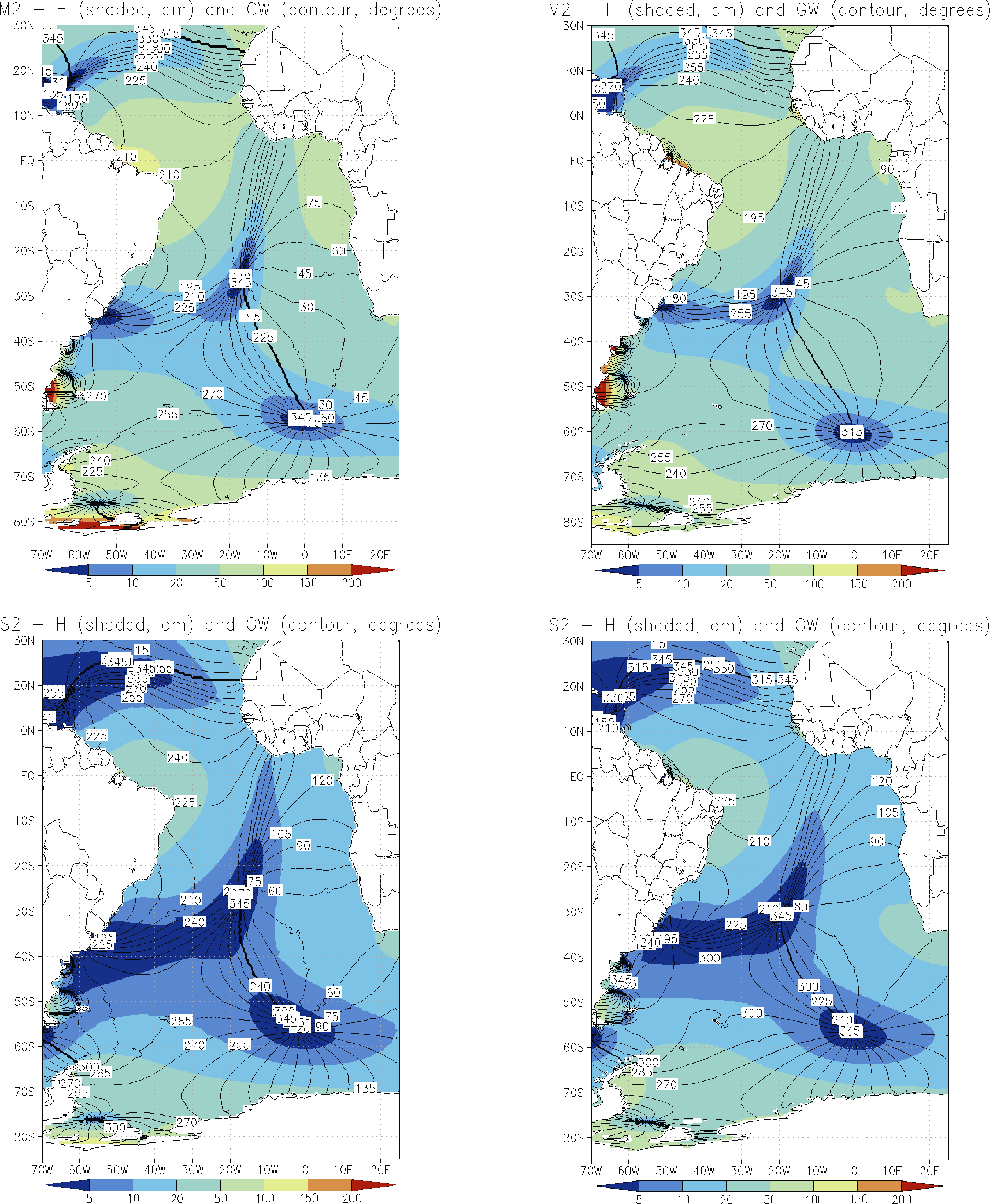 | Figure 1 Cotidal charts of amplitude (shaded; units: cm) and phase with respect to Greenwich Mean Time (contours; units: °) obtained by the model for M2 and S2 tidal constituents (upper- and lower-left panels, respectively) and represented by the TPXO tidal model (upper- and lower-right panels, respectively). |
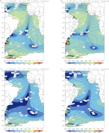
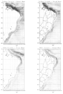
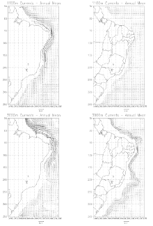
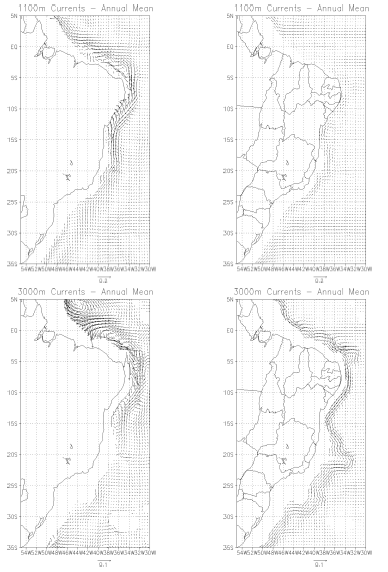
The amphidromic points, and the corresponding combination of tidal wave propagation around them, were related to the configuration of the domain at high latitudes: the presence of the Weddell Sea is particularly important in determining the small astronomic tide amplitudes observed in southern Brazil and the Prata Estuary. This was the result of the superposition of the counterclockwise gyre around the amphidrome located at (27°S, 018°W) with the clockwise gyre around the amphidrome located at (50°S, 060°W), close to Malvinas Island. The combination of both wave propagations had a destructive effect over the amplitudes of the astronomic tides between 30°S and 40°S, close to the coast and further east. Considering annual averages of general circulation (Fig. 2), the representations for the surface, 200 m,1100 m and 3000 m captured relevant aspects related to the western boundary currents along the Brazilian coast, as well as the bifurcation of the South Equatorial Current (SEC), which moves southward in deeper layers. For comparison with the reference fields, Simple Ocean Data Assimilation (SODA) version 2.2.4 averages are also presented in Fig. 2. At the surface, good agreement was found between model and reference, e.g., the region of formation of the North Brazil Current around 10°S, as well as the formation of the Brazil Current itself between 10°S and 15°S. At 200 m depth, the retroflection of the North Brazil Current was more prominent and extended further southward compared to the reference. The location of the SEC bifurcation at 200 m was around 20°S: its contribution to the North Brazil Undercurrent is very important, and this feature was well captured by the model. At 1100 m, the western boundary northward flow associated with the SEC bifurcation started at around 25°S, in-keeping with SODA2.2.4, but the intensities were overestimated. Some anticyclonic structures at the north shelf, which were not present in the reference, were also observed. At 3000 m, the existence of a northward flow had no correspondence with the reference, and the southward flow close to the coast associated to North Atlantic Deep Water (NADW) was observed, but at a lower intensity and with a less distinct spatial distribution than in the reference fields.
 | Figure 2 Annual averages of currents at different depths (units: m s-1), according to the vector scale at the bottom of each figure. Model results are presented in the left-hand panels and SODA2.2.4 results in the right-hand panels for the surface (upper row), 200 m (second row), 1100 m (third row), and 3000 m depths (lower row). |
 | Figure 2 (Continued) |
This paper presents initial efforts to reach a robust simulation system for tides and wind-driven circulation for the coast of Brazil. The implementation of a customized version of POM to the tropical and southern Atlantic Ocean is presented, in which we demonstrate that the system successfully captured the essence of 3D large-scale circulation, as well as the behavior of the propagation of tidal waves and their general characteristics. An interesting aspect concerning large-scale tides in the South Atlantic is the relevance of the Weddell Sea for the combination and superposition of the amphidromic systems. This is particularly important for the small astronomic amplitudes observed around the South Brazil Shelf and the Prata Estuary.
Despite the adopted latitudinal and longitudinal resolution of 0.5°, which is neither eddy-permitting nor eddy- resolving, the proposed system was able to represent high-frequency variability of sea level and currents. Based on that, and considering the limited availability of operational forecasts of surface wind fields, the simulation system was used to regularly supply seven-day sea level predictions and 3D currents for the whole Brazilian coast. The results obtained were quite representative, and they could also be used to supply initial and boundary conditions for the three shelf domains that cover the whole coast of Brazil. The products are freely available at www. master.iag.usp.br.
Some improvements to the system are planned. These include alternative large-scale atmospheric forcings (such as CPTEC-Brazil (Centro de Previs o do Tempo e Estudos Climáticos) and European Centre for Medium-Range Weather Forecasts (ECMWF), etc.), the use of distinct climatologies (such as CSIRO (Commonwealth Scientific and Industrial Research Organisation) Atlas of Regional Seas (CARS)) and/or model outputs (such as Ocean Modelling, Analysis, and Prediction System (OceanMAPS)), and long-term hindcast integrations for the detection of tendencies and long-term variabilities.
Acknowledgements. The authors thank the Brazilian agencies FAPESP (Sao Paulo State Research Agency) and CNPq (National Council for Scientific and Technological Development) for funding throughout the development of this work.
| 1 |
|
| 2 |
|
| 3 |
|
| 4 |
|
| 5 |
|
| 6 |
|
| 7 |
|