


The Effects of Land Cover Change on Regional Climate over the Eastern Part of Northwest China
[HAN Zhen-Yu1, 2 , GAO Xue-Jie3, *  , SHI Ying
1 , XU Ying1 ]
, SHI Ying|
|


Citation: Han, Z.-Y., X.-J. Gao, Y. Shi, et al., 2015: The effects of land cover change on regional climate over the eastern part of Northwest China, Atmos. Oceanic Sci. Lett., 8, 153-159.
doi:10.3878/AOSL20150007.
Received 9 January 2015; revised 28 January 2015; accepted 3 February 2015; published 16 May 2015A regional climate model (RegCM4) is employed to investigate the impacts of land use/cover change (LUCC) on the climate over the eastern part of Northwest China (ENW) in the periods of 2001 and 2011. The results indicated that the LUCC in ENW, which was characterized by desert retreat, reforestation, and farmland expansion, led to significant local changes in surface air temperature (within ~0.3°C) and slight regional changes in precipitation (within ~15%) in summer. In the desert retreat area, the net absorbed shortwave radiation had a greater influence than evaporative cooling, leading to increases in the daily mean and maximum temperature. Besides, the daily mean and maximum temperatures increased in the reforestation area but decreased in the farmland expansion area. As surface albedo showed no significant change in these regions, the temperature increase in the reforestation area can be attributed to a decrease in evaporation, while the opposite effect appears to have been the case in the farmland expansion area.
Climate impacts of land use/cover change (LUCC) have been found in local, regional, and global trends in modern atmospheric temperature records and other relevant climatic indicators. LUCC, together with greenhouse gas and aerosol emissions, contribute to anthropogenic climate changes (Mahmood et al., 2010). The LUCC effects on climate are more significant at regional and local scales.
Substantial land cover change has occurred over China due to its long history of agricultural activities and the high density of population. In recent decades, efforts have been made to restore ecosystems through a series of projects to return the farmland to forests or grassland. The focus of the projects is over steep mountain slopes to prevent soil erosion and at the edges of deserts to halt their expansion. Meanwhile, benefiting from agricultural techniques and regional climatic change suitable for agriculture, as well as the population burden, large areas of forest and grassland have been transformed into farmland (e.g., Liu et al., 2010). The mixture of these activities is bound to lead to changes in local and regional climate. To assess the possible climatic effects of LUCC over these areas is important in terms of the local sustainable development of the socioeconomic and ecological environment.
In the present study, the eastern part of Northwest China (ENW) is selected to investigate the climatic effects of LUCC in the last decade. ENW is located in the transition zone from cropland/forest in the east and south to desert in the north and at the edge of the Tibetan Plateau in the west. The region (Fig. 1), consisting of part of the provinces of Shaanxi and Gansu, the whole of Ningxia, and part of the Inner Mongolia Autonomous Region, is characterized by poor climatic conditions, with water shortages and a fragile ecological environment.
A high resolution regional climate model (RCM), Regional Climate Model version 4 (RegCM4), is employed in this study. RCMs have been widely used in LUCC studies over China and elsewhere in the world (Gao et al., 2003, 2007; Sen et al., 2004; Zhang et al., 2005; Kueppers et al., 2007; Anav et al., 2010; Dong et al., 2013). To distinguish the actual effect of LUCC from random errors caused by individual case selection, the climate effects of LUCC are analyzed based on two groups of multi-year RegCM4 ensemble simulations, using the land cover data of 2001 and 2011, respectively. Followed this introduction, a brief description of the model, data and experimental design is provided in section 2. The results, as well as a mechanistic analysis, are presented in section 3, and conclusions are given in section 4.
RegCM4 was developed at the Abdus Salam International Centre for Theoretical Physics (Giorgi et al., 2012). It is a hydrostatic, compressible model with a terrain-following sigma vertical coordinate system. The RegCM series of models has been widely used over China for a variety of applications, demonstrating good performance in reproducing the present climate over the region (e.g., Liu et al., 1994; Gao et al., 2001, 2006, 2013; Ju and Wang, 2006; Gu et al., 2012; Zou and Xie, 2012). The physical schemes employed in our study include the cumulus parameterization scheme of the Massachusetts Institute of Technology-Emanuel with relativity humidity criteria (Zou et al., 2014), the Sub-grid Explicit Moisture Scheme, the radiation package of the NCAR Community Climate Model version 3, and the non-local PBL scheme. Of the most important processes in LUCC studies, the land surface processes are parameterized through the Biosphere-Atmosphere Transfer Scheme (BATS; Dickinson et al., 1993) with sub-grid consideration used to present the land surface types at a much higher resolution (Giorgi et al., 2003). Note that this SUB-BATS scheme has been used to study the climate effects of the Three Gorges Reservoir by Wu et al. (2012).
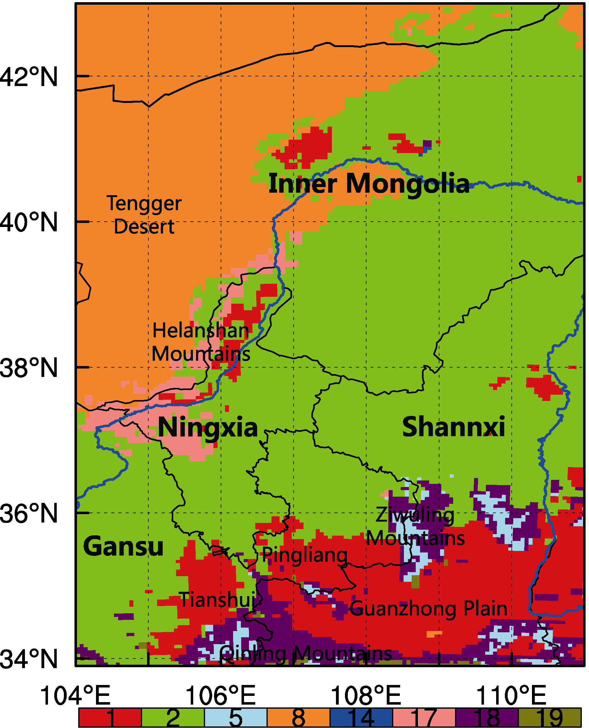 | Figure 1 Land cover of ENW in 2011 (legend corresponds to the following: 1 represents crop/mixed farming; 2, short grass; 5, deciduous broadleaf trees; 8, desert; 14, inland water; 17, deciduous shrubs; 18, mixed forest; 19, forest/field mosaic). |
The model domain covers the ENW region (34-43° N, 104-111° E) at a grid-spacing of 25 km, including 60 grid points in the north-south direction and 64 in the east-west direction (Fig. 1). Each coarse grid cell is then divided into 5 × 5 sub-grid cells to represent the land surface at a resolution of 5 × 5 km. The model was run at its standard vertical configuration of 18 sigma layers and model top at 50 hPa. The initial and time-evolving lateral boundary conditions were derived from the European Centre for Medium-Range Weather Forecasts Interim Reanalysis. Two groups of five-year experiments (E01 and E11) for the period of November 2000 to December 2005 were performed, using the land surface coverage in 2001 and 2011, respectively. E01 and E11 each consisted of an ensemble of three different integrations that started from different initial conditions. The first month was considered as spin-up time and is excluded in the analysis.
First, the three-member ensemble mean was calculated for E01 and E11. Then, we analyzed the five-year average differences between the two experiments (E11 minus E01) to show the LUCC effects on climate over the ENW region. We focus our analysis on surface air temperature, precipitation, and energy flux in summer (June-July-August), winter (December-January-February), and the whole year (annual mean) in this study. The point-by-point, two-tailed Student’ s t-test is used to test the statistical significance of the changes in mean surface air temperature, precipitation, and energy flux. Changes passing the 90% confidence level in the t-test are regarded as significant (P < 0.10). To separate the effects of different LUCC, average changes over different types of LUCC are also analyzed.
The land cover data used in this study were extracted from the Moderate Resolution Imaging Spectroradiometer (MODIS) land cover data product (Friedl et al., 2010). This dataset has an original spatial resolution of 500 m and adopts the International Geosphere-Biosphere Programme land cover classification. The dataset is first reclassified following that of the BATS classification, which includes 20 land cover types, and then later up-scaled to the 5 × 5 km resolution to meet the requirement of the BATS scheme. Checking of consistencies before and after the reclassification and upscaling is conducted to ensure the accuracy of the processes, by gathering the types into five broader categories of desert, grassland, shrub, farmland, and forest.
Figure 1 shows the land cover data of 2011 over the ENW to be input into RegCM4. As can be seen, there are six main land cover types including desert, grassland, shrub, farmland (crop), deciduous forest, and mixed forest. The farmland is mainly located in the southern part of ENW, including the Tianshui and Pingliang areas in eastern Gansu, and Guanzhong Plain in Shaanxi. Widely spread grass coverage is found in the arid zone of the central part of ENW. Forest is mainly located over Ziwuling Mountains at the junction area of Shaanxi and Gansu, as well as the northern slope of Qinling Mountains. Shrubs are found in the west of Ningxia over Helanshan Mountains, with desert distribution (the edge of the Tengger Desert) located to the west of it.
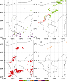
The land cover data of the ENW in 2001 and 2011 are overlaid to show the conversion of each land cover type over the area. The land cover change is mainly characterized by a decrease of farmland (reforestation), decrease of desert (desert retreat), and an increase of farmland (farmland expansion), as shown in Fig. 2. The numbers of grid changes for those conversions are 235, 785, and 1221, corresponding to actual areas of about 5875, 19625, and 30525 km2, respectively. By contrast, the increase in desert (desert expansion) is no more than 1425 km2 (Fig. 2d). Areas with decreased farmland (converted into grass and forest) are mainly scattered across the southern and western part of Shaanxi, as well as over Ningxia (Fig. 2a). The desert retreat mainly converted to grass and shrub at the eastern edge of Tengger Desert (Fig. 2b). The newly increased farmland is mainly located in Tianshui and Pingliang, converted from grass and forest (Fig. 2c).
 | Figure 2 Land use/cover change (LUCC) from 2001 to 2011: (a) reforestation, (b) desert retreat, (c) farmland expansion, and (d) desert expansion. (legend corresponds to the following: 1 represents crop/mixed farming; 2, short grass; 5, deciduous broadleaf trees; 8, desert; 14, inland water; 17, deciduous shrubs; 18, mixed forest; 19, forest/field mosaic). |
Figures 3a-c show the spatial distribution of temperature change due to LUCC in summer, winter, and the whole year (annual mean). In summer, a significant warming can be found over the reforestation area (central Shaanxi and northern Inner Mongolia) and the desert retreat area (the junction of Inner Mongolia and western Ningxia). The maximum value is greater than 0.2° C. Meanwhile, the temperature decreases by 0.1° C-0.3° C over the farmland expansion areas in eastern Gansu (Fig. 3a). In winter, the warming signal only appears in the reforestation area of northern Inner Mongolia, with a maximum greater than 1.0° C. A decrease of temperature in the range of 0.1° C-0.3° C is observed in the desert retreat area, which lies at the junction of Inner Mongolia and western Ningxia (Fig. 3b). Most of these local changes in summer and winter are statistically significant at the 90% confidence level. In terms of the annual mean temperature, the value of decrease is very low, while significant warming can only be found in a small part of the reforestation area in northern Inner Mongolia (Fig. 3c).
 | Figure 3 The change pattern of (a-c) mean surface air temperature (units: ° C) and (d-f) precipitation (%) in (a, d) summer, (b, e) winter, and (c, f) the whole year. The areas exceeding the 90% confidence level are dotted. |
Overall, the temperature changes due to LUCC are more significant in summer compared to winter. These significant changes are mainly limited to a local scale around the grids with land cover changes. Changes of temperature corresponding to each kind of LUCC are summarized in Table 1. The temperature change due to desert retreat is in an opposite direction in summer and winter, while reforestation-related temperature rises for the whole year, and the cooling effect corresponding to farmland expansion, appears only in summer.
Figures 3d-f show the spatial distribution of precipitation change due to LUCC. It is found that changes in precipitation are more remarkable in summer compared to winter and the annual mean. Sensitivity experiments using idealized LUCC scenarios often show significant large- scale changes in precipitation (Gao et al., 2007; Zhang et al., 2010). But in our case, with much less change of land cover, the effects are not systematic. Furthermore, precipitation change due to LUCC is not consistent in both the reforestation and desert retreat case, i.e. in some areas, reforestation leads to an increase, but in other areas it leads to a decrease, although most of the changes are statistically not significant (P < 0.10). Around the northeastern border of ENW and the farmland expansion area in eastern Gansu, a significant increase in precipitation is found, with the largest value in excess of 15% (Fig. 3d). Only slight changes are found in parts of the region in winter (Fig. 3e). The spatial distribution of annual precipitation change shows similarities with that of summer as expected, but to a lesser extent (Fig. 3f). Compared to the more local effects of LUCC on temperature, the LUCC influences on precipitation tend to extend to a larger spatial scale.
| Table 1 The average change of near-surface temperature (units: ° C) corresponding to each kind of land use/cover change (LUCC) and the percentage of grids (in brackets) over which the direction of change agrees with that of the average. |
Based on the above analysis, LUCC shows a more significant effect on surface air temperature in summer, and thus the surface energy budget changes in summer are selected to help comprehend the underlying mechanism. Figure 4a shows the dependence of surface temperature changes on changes in latent heat flux (LH) and shortwave radiation (SW). Downward flux is counted as positive and upward flux as negative. If ∆ LH = 0, the surface temperature may increase up to 0.5° C as SW increases. Positive and negative changes in temperature are located on different sides of the diagonal line (LH + SW = 0). Over almost all of the grids where ∆ (LH + SW) > 0 (meaning more surface energy), the surface temperature increases. This distribution indicates that the integrated effect of SW and LH is the dominant factor involved in the surface air temperature change.
The albedo of grassland or shrub is much less than that of desert in the summer. Therefore, the LUCC dominated by desert retreat will eventually result in lower albedo and consequently more solar radiation absorption (Fig. 4b). These changes are mostly significant at the 90% confidence level. Consequently, the surface temperature should be higher because of more shortwave radiation absorption. On the other hand, the desert retreat not only changes the surface albedo, but also the soil moisture, which is usually higher on better vegetated land. Subsequently, the land surface heat is apt to get into the atmosphere in the form of latent heat, which may lead to a lower temperature due to evaporation (Fig. 4c). The simulation shows that the integrated effect of SW and LH can give rise to a surface temperature increase (Fig. 3a). This effect can be well reflected by the change of daily minimum and maximum temperature (Tmin and Tmax). The warming effect due to SW change results in a Tmax increase, while the cooling effect due to LH change leads to a Tmin decrease (Table 2).
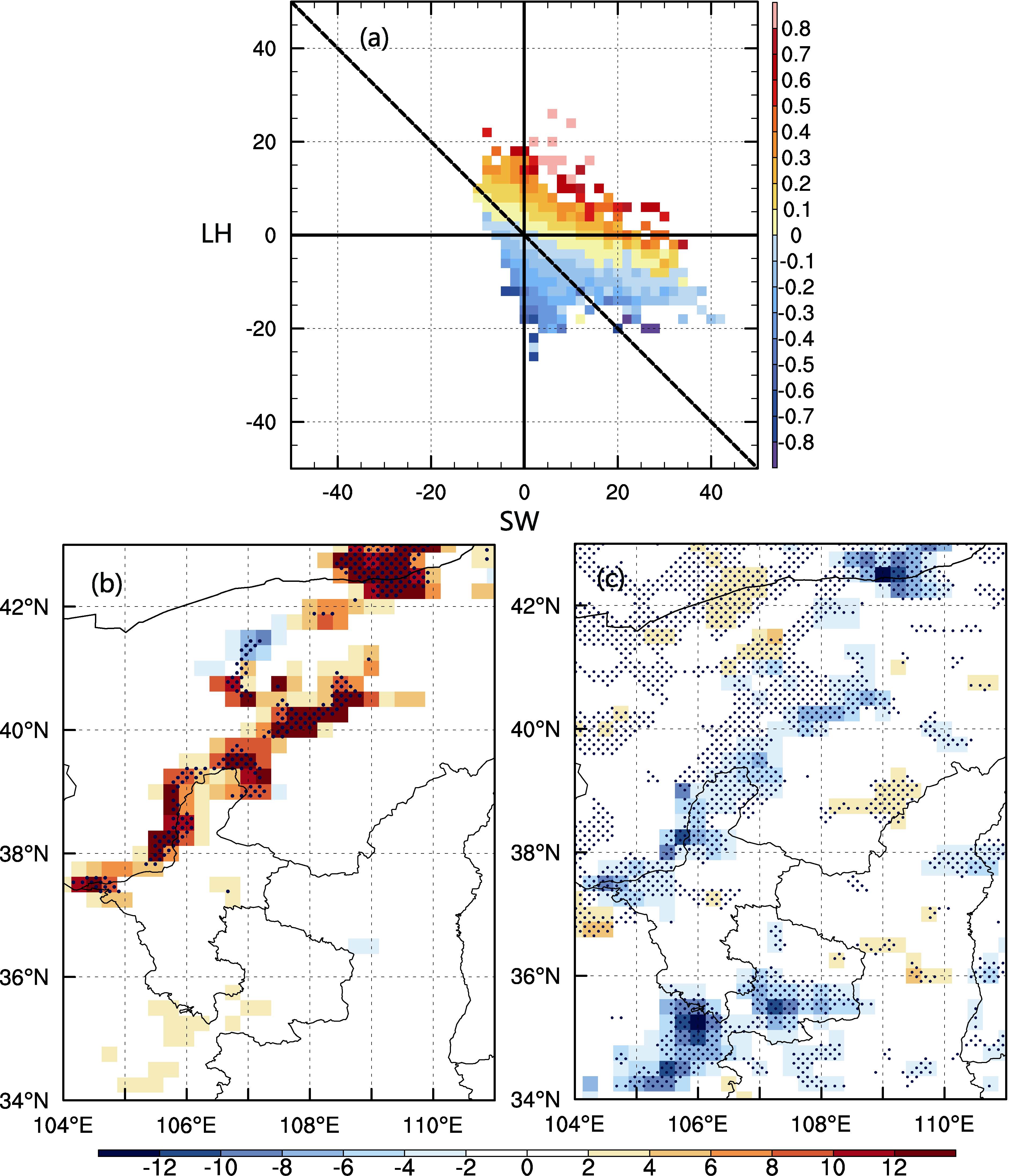 | Figure 4 (a) Changes in surface air temperature (shading; units: ° C) against changes of SW and LH (x-axis and y-axis; units: W m-2) in summer. The figure is based on single grids over the whole area. The change pattern of (b) SW and (c) LH in summer. The areas exceeding the 90% confidence level are dotted. Downward radiation is counted as positive and upward radiation as negative. |
Farmland has a similar albedo to natural vegetation in summer, so there are no significant changes of SW in the reforestation and farmland expansion areas (Fig. 4b). But the increases and decreases of LH (decrease and increase of evaporation) are significant relating to reforestation and farmland expansion, due to larger leaf area index and moister soil under crops. These local changes are significant at the 90% confidence level. Furthermore, this LH change has a greater effect on surface air temperature during the daytime, as indicated by the Tmax in Table 2.
Different types of land cover differ greatly in their physical characteristics, resulting in significant differences in the energy budget of the land surface and then different impacts on regional climate change. Based on the high resolution LUCC data from MODIS, simulations using a high resolution regional climate model were conducted to study the possible regional climate change due to LUCC over the ENW region. The main results are as follows:
(1) The land use/cover change in ENW during 2001- 2011 is mainly characterized by desert retreat at the eastern edge of Tengger Desert, reforestation in southern Shaanxi, and farmland expansion in Tianshui and Pingliang of eastern Gansu.
(2) LUCC shows greater effects on regional climate in summer. The significant changes in temperature (within ~0.3° C) are limited within local areas as a direct response to LUCC, while changes in precipitation (within ~15%) may extend to a larger scale, but are not significant.
(3) The integrated effect of SW and LH is the dominant factor affecting surface air temperature change in summer. In the desert retreat area, SW heating has a stronger influence than LH cooling, which leads to increases of daily mean and maximum temperature. In the reforestation and farmland expansion area, with no significant changes in surface albedo, the daily mean and maximum temperature change is mainly caused by the change of LH. Reforestation leads to a decrease in evaporation and an increase in temperature, while the effect of farmland expansion is opposite.
| Table 2 The change of shortwave radiation (SW) and latent heat flux (LH) (units: W m-2), as well as Tmax and Tmin (units: ° C) corresponding to each kind of LUCC in summer. |
| 1 |
|
| 2 |
|
| 3 |
|
| 4 |
|
| 5 |
|
| 6 |
|
| 7 |
|
| 8 |
|
| 9 |
|
| 10 |
|
| 11 |
|
| 12 |
|
| 13 |
|
| 14 |
|
| 15 |
|
| 16 |
|
| 17 |
|
| 18 |
|
| 19 |
|
| 20 |
|
| 21 |
|
| 22 |
|
| 23 |
|