Dynamical Downscaling of the Twentieth Century Reanalysis for ChinaŁşClimatic Means during 1981-2010
[KONG Xiang-Hui1, 2 , BI Xun-Qiang1, *  ]
]
]
|
|


Citation: Kong, X.-H., and X.-Q. Bi, 2015: Dynamical downscaling of the twentieth century reanalysis for China: Climatic means during 1981-2010, Atmos. Oceanic Sci. Lett., 8, 166-173.
doi:10.3878/AOSL20140099.
Received 29 December 2014; revised 4 February 2015; accepted 9 February 2015; published 16 May 2015This study presents a dynamically downscaled climatology over East Asia using the non-hydrostatic Weather Research and Forecasting (WRF) model, forced by the Twentieth Century Reanalysis (20CR-v2). The whole experiment is a 111-year (1900-2010) continuous run at 50 km horizontal resolution. Comparisons of climatic means and seasonal cycles among observations, 20CR-v2, and WRF results during the last 30 years (1981-2010) in China are presented, with a focus on surface air temperature and precipitation in both summer and winter. The WRF results reproduce the main features of surface air temperature in the two seasons in China, and outperform 20CR-v2 in regional details due to topographic forcing. Summer surface air temperature biases are reduced by as much as 1°C-2°C. For precipitation, the simulation results reproduce the decreasing pattern from Southeast to Northwest China in winter. For summer rainfall, the WRF simulation results reproduce the correct magnitude and position of heavy rainfall around the southeastern coastal area, and are better than 20CR-v2. One of the significant improvements is that an unrealistic center of summer precipitation in Southeast China present in 20CR-v2 is eliminated. However, the simulated results underestimate winter surface air temperature in northern China and winter rainfall in some regions in southeastern China. The mean seasonal cycles of surface air temperature and precipitation are captured well over most of sub-regions by the WRF model.
The globally averaged surface temperature data, as calculated by a linear trend, show a warming of 0.85° C (± 0.2° C) over the period 1880-2012 according to the Fifth Assessment Report of the Intergovernmental Panel on Climate Change (IPCC, 2013). A changing climate demonstrated by global warming would lead to changes in the frequency, intensity, spatial extent, duration, and timing of extreme weather and climate events, and can result in unprecedented extreme weather and climate events (IPCC, 2012). However, due to a lack of long-term observation series, little is known about the variation in drought and flood occurrences under the background of climate change in China. Before the 1950s, there were few weather stations in China. For instance, the number of stations used in version 3.21 of terrestrial surface climate produced by the Climatic Research Unit of the University of East Anglia (CRU TS3.21) for the year 1930 in China is less than 100 (Harris et al., 2014), and in version 4 of the Climatic Research Unit Temperature dataset includes short-range observations over China (Osborn and Jones, 2014). In this regard, observational data are insufficient for revealing the long-term trend in China during the last 60 years with respect to global warming, not to mention the period before 1950.
Two long-term global reanalysis datasets are currently available, as a result of the increasing ability of dynamical reanalysis by global numerical models. One is version 2 of the National Oceanic and Atmospheric Administration (NOAA) Twentieth Century Reanalysis (20CR-v2; Compo et al., 2011), and the other is the European Center for Medium-Range Weather Forecasts (ECMWF) 20th Century Reanalysis (ERA-20C; Hersbach et al., 2015). These reanalysis datasets, produced by the latest data assimilation system, possess great advantages in investigating the issue of the response of the climate system to global warming. However, the horizontal resolution of these datasets is coarse, typically about 100 km (in both the zonal and meridional direction), and insufficient to adequately capture regional-scale topographic forcing.
Dynamical downscaling using regional climate models (RCMs) is a common approach to overcome these problems. Constituting an important downscaling technique, RCMs were first proposed by Dickinson et al. (1989) and Giorgi (1990) from the idea of limited-area models. In studies on East Asian climate, RCMs have been extensively used in the last decade to represent regional circulations due to their rather high spatial and temporal resolutions. For example, Gao et al. (2011) applied an RCM (International Centre for Theoretical Physics RegCM3) driven a GCM (National Aeronautics and Space Administration FvGCM) at a resolution of 20 km for both present-day climate (1961-90) and future climate (2071-2100, under the IPCC A2 scenario) over East Asia. Yuan et al. (2012) analyzed ensemble downscaling seasonal forecasts of winter precipitation in China during 1982-2008 using the Weather Research and Forecasting (WRF) model driven by the National Centers for Environmental Prediction Climate Forecast System. Zhao (2013) used an RCM (the Regional Integrated Environment Modeling System, version 2) driven by National Centers for Environmental Prediction/National Center for Atmospheric Research reanalysis data to simulate precipitation over East Asia. To date, however, there has been a lack of continuous century-scale simulation studies over East Asia.
Compared with previous simulations, we use the latest 20CR-v2 reanalysis to drive the WRF model and carry out a 111-year continuous simulation (from 1900 to 2010). To the best of our knowledge, this is the first time that 20CR-v2 has been used as the initial and boundary conditions for an RCM study over East Asia. Previous studies show that 20CR-v2 is able to represent the atmospheric circulation pattern over East Asia in the last 100 years (Fan and Liu, 2013; Zhu, 2013). Through the downscaling simulation for 111 years, we aim to obtain a longer-term dataset than previous studies, and thus provide a basis for further analysis of the spatiotemporal distribution and variation of drought and flood occurrences in China.
Given the abundance and reliability of observational records since 1981, the climatic means and seasonal cycles of surface air temperature and precipitation are compared over the last 30 years in this study.
The RCM used in the present study is the non-hydrostatic Advanced Research WRF model, version 3.5.1 (WRF-ARW; Skamarock et al., 2008), and the pre-processing interface is prepared for adaption to 20CR-v2 data. This paper utilizes WRF with the following experiment design: The model is continuously integrated for 111 years from 1 January 1900 to 31 December 2010. As proposed by Giorgi and Mearns (1999), RCMs reach a strict equilibrium only after years of simulation. Thus, the first year is regarded as model spin-up.
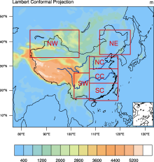
Figure 1 displays the domain and terrain in this study. The model domain is centered at (36° N, 105° E). The integration runs on Lambert projected grids, with 139 grid points in the x direction and 119 grid points in the y direction. The domain covers most of continental East Asia. In view of the large size of the computational domain and long integration time, a 50 km horizontal resolution is chosen. The lateral buffer zones are located across nine grids on each outermost side. There are 29 vertical levels, with the model top at 50 hPa. Six sub-regions of China, shown in Fig. 1, are selected for later statistical analysis: South China, Central China, North China, Northeast China, Southwest China, and Northwest China.
The WRF model contains a large number of physical parameterizations. In this present work, the physics parameterization schemes used are as follows: For deep cumulus convection, we use the Kain-Fritsch scheme (Kain and Fritsch, 1993; Kain, 2004). The Community Atmosphere Model solar shortwave and terrestrial longwave radiation schemes are selected (Collins et al., 2004). The chosen microphysics process scheme is the WRF Single-Moment six-Class Microphysical scheme, including graupel and associated processes (Hong and Lim, 2006). The planetary boundary layer is parameterized using the Yonsei University scheme (Hong et al., 2006). The land surface scheme is a four-layer Noah model (Chen and Dudhia, 2001; Ek et al., 2003), used to calculate soil temperature, soil and canopy moisture etc. Finally, the scheme for skin SST calculation is based on Zeng and Beljaars (2005).
 | Figure 1 WRF model domain and topography (units: m). Shown in red boxes are the six sub-regions used for sub-continental-scale analysis: SC, South China; CC, central China; NC, North China; NE, Northeast China; SW, Southwest China; NW, Northwest China. |
The WRF model is forced by data from 20CR-v2. The 20CR-v2 dataset is a NOAA product, and is the first estimate of global tropospheric variability available from 1871 to 2012 (Compo et al., 2011). The simulated initial and lateral boundary conditions are updated every 6 h at a resolution of 2° × 2° for the entire 111 years. For the SST field, the monthly Met Office Hadley Centre Sea Ice and Sea Surface Temperature dataset (HadISST; Rayner et al., 2003) is used before the year 1981, and is replaced later by version 2 of the daily NOAA Optimum Interpolation Sea Surface Temperature high-resolution dataset (OISST; Reynolds et al., 2007).
To validate the WRF model, the observational surface air temperature climatology used is from the high-resolution (0.5° × 0.5° ) grids of the monthly CRU TS3.21 dataset. The observational precipitation climatology is from transformed 0.5° × 0.5° data based on over 2400 observational stations (Wu and Gao, 2013), hereinafter referred to as CN05.1.
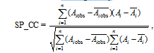
In this paper, we choose the seasonal spatial pattern correlation coefficient (SP_CC) to quantitatively assess the 2 m air temperature and precipitation among observations, 20CR-v2, and WRF results. This statistic has been used in previous studies (Zhou and Qian, 1995; Gao et al., 2011; Liu et al., 2013) and is given by
In this section, comparisons among observations, 20CR-v2, and WRF simulation results are presented for both winter and summer during the period 1981-2010, represented by December-January-February (DJF, boreal winter) and June-July-August (JJA, boreal summer), respectively.
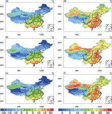
Figure 2 show that, during boreal winter, observational surface air temperature over China (Fig. 2a) declines from south to north. Warm centers are mainly located in the Sichuan Basin and in Guangdong and Yunnan provinces. Cold centers are clearly located in Northeast China and in mountainous regions (e.g., the Qilian, Tianshan, and Kunlun mountains), as indicated by CRU TS3.21. Compared with CRU TS3.21, 20CR-v2 (Fig. 2b) generally
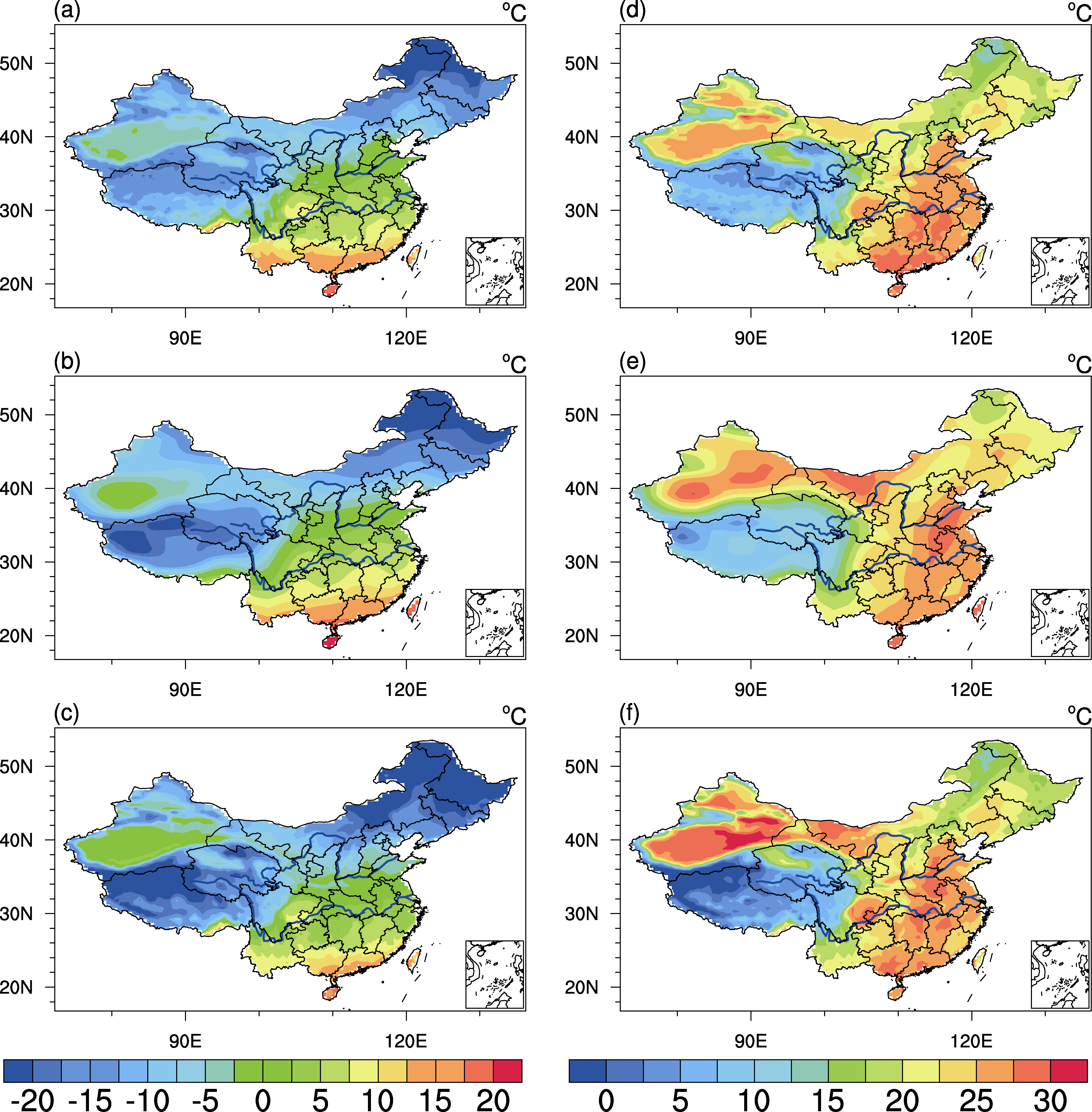 | Figure 2 Seasonal-averaged 2 m air temperature (units: ° C) distribution in (a-c) winter and (d-f) summer for the period 1981-2010 from (a, d) version 3.21 of terrestrial surface climate produced by the Climatic Research Unit (CRU TS3.21), (b, e) the Twentieth Century Reanalysis (20CR-v2), and (c, f) the non-hydrostatic Weather Research and Forecasting (WRF) model simulations. |
reproduces the spatial pattern well in winter. It is well known that temperature is closely related to altitude, following the lapse-rate relationship. Over the Tibetan Plateau, the 20CR-v2 pattern reflects this relationship. However, 20CR-v2 clearly fails to reproduce the cold center over the Qilian Mountains and the warm center in the Sichuan Basin, due to its coarse resolution. The WRF downscaling results (Fig. 2c) reproduce well not only the spatial patterns but also the regional details induced by topography, as it operates at a higher spatial resolution than 20CR-v2.
During boreal summer, CRU TS3.21 (Fig. 2d) exhibits a northeast-southwest pattern over eastern China. Warm centers are mainly located in Jiangxi and Hunan provinces, the Sichuan Basin, and the desert region in Xinjiang. Both 20CR-v2 (Fig. 2e) and the WRF simulation results (Fig. 2f) reproduce well the observational surface air temperature pattern in summer. However, the 20CR-v2 surface air temperature exhibits a north-south pattern over eastern China, and with smoother contours than observations and the WRF simulation. The warm center of 20CR-v2 also extends too far north in eastern China. The WRF simulation results capture the broad spatial pattern of CRU TS3.21, with coincidence in both warm and cold centers. From the distribution of the seasonal-mean surface air temperature biases (not shown), 20CR-v2 shows prominent positive bias, as much as 2° C-4° C, over southern China, northwestern China, and northern Northeast China. 20CR-v2 mainly presents negative bias for other regions. The WRF results reproduce a significant negative bias in continental China in winter, except in Xinjiang. In summer, 20CR-v2 presents negative biases over southern China and positive biases over northern and northwestern China. The WRF surface air temperature biases are much reduced compared with those of 20CR-v2, especially over eastern China (within 2° C).
| Table 1 The area-averaged surface air temperature biases (units: ° C) from the Twentieth Century Reanalysis (20CR-v2) minus version 3.21 of terrestrial surface climate produced by the Climatic Research Unit (CRU TS3.21) and the non-hydrostatic Weather Research and Forecasting (WRF) results minus CRU TS3.21 over the six sub-regions in winter and summer for the period 1981-2010. Bold numbers mean that WRF outperforms 20CR-v2. |
Northwest China). The WRF results significantly underestimate surface air temperature over North China and Northeast China. In summer, the WRF area-averaged surface air temperature biases are smaller than for 20CR-v2 over all sub-regions. The WRF result biases are even below 0.6° C over Central China, North China, Northeast China, and Southwest China.
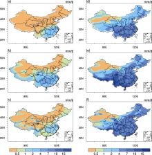
Figure 3 show that, during boreal winter, observational precipitation over China (Fig. 3a) declines from the southeast to northwest, with a maximum (2 mm d-1) located in the southeastern coastal region. The precipitation amount in 20CR-v2 declines from south to north, and the maximum appears in the area south of the Yangtze River, which is not consistent with CN05.1. The WRF-simulated precipitation (Fig. 3c) reproduces the spatial pattern of CN05.1 well. In particular, the WRF results successfully capture not only the maximum in Southeast China, but also the local precipitation center (e.g., over the Tianshan Mountains).
During boreal summer, observational precipitation declines from southeast to northeast, which is mainly caused by the East Asia summer monsoon (Ding, 1994). In southeastern coastal regions and the southern part of Guangdong and Yunnan provinces, the 30-year average JJA precipitation rate is greater than 7 mm d-1. The maximum summer precipitation in 20CR-v2 is located in Southwest China (e.g., the Sichuan Basin and Yunnan Province), which does not coincide with observations. The WRF simulation results accurately reproduce the precipitation pattern in summer, and capture the correct magnitude of the precipitation center along the southeastern coastal lines. Furthermore, one of the more significant improvements of the WRF simulation is that the unrealistic center in Southwest China in 20CR-v2 is eliminated.
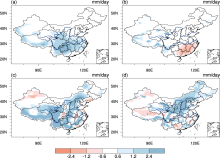
As shown in Fig. 4a, 20CR-v2 generally overestimates winter rainfall over China. Over Southwest China and Central China in particular, the overestimation is up to 90%. The WRF results (Fig. 4b) underestimate winter rainfall over southeastern China. In summer, 20CR-v2 (Fig. 4c) significantly overestimates rainfall over Southwest China and North China, and underestimates it in some regions of eastern China. The WRF results (Fig. 4d) outperform 20CR-v2 in terms of eliminating positive biases in summer over Southwest China and South China. However, the WRF result also reproduces positive biases over North China, which may be partly from the forcing by 20CR-v2.
Table 2 shows that, in winter, the biases from the WRF results are smaller than those from 20CR-v2 over most of China (Central, North, Southwest, and Northwest China), except two sub-regions (South China and Northeast China). In summer, the WRF results outperform 20CR-v2 over four sub-regions (South, Central, Southwest, and Northwest China). 20CR-v2 shows positive biases of rainfall in summer over North China and Northeast China, enhanced by WRF, exceeding 2 mm d-1 over some areas.
 | Figure 3 Seasonal-averaged precipitation (units: mm d-1) distribution in (a-c) winter and (d-f) summer for the period 1981-2010 from (a, d) CN05.1, (b, e) 20CR-v2, and (c, f) the WRF model simulations. |
 | Figure 4 Seasonal-averaged percentage of precipitation biases (units: mm d-1) distribution in (a, b) winter and (c, d) summer for the period 1981-2010 from (a, c) 20CR-v2 minus CN05.1 and (b, d) the WRF model simulations minus CN05.1. |
| Table 2 The area-averaged precipitation bias (units: mm d-1) from 20CR-v2 minus CN05.1 and the WRF results minus CN05.1 over the six sub-regions in winter and summer for the period 1981-2010. Bold numbers mean that WRF outperforms 20CR-v2. |
Table 3 shows that, for surface air temperature, the SP_CCs between CRU TS3.21 and the WRF-simulated result are 0.974 and 0.95, higher than for 20CR-v2. For precipitation, the SP_CCs between CN05.1 and WRF are 0.72 and 0.68 in winter and summer, also higher than for 20CR-v2. In this regard, the WRF model outperforms the forcing 20CR-v2.
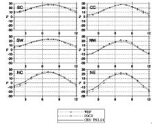
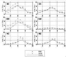
In this subsection, we analyze the mean seasonal cycles of surface air temperature and precipitation for the six sub-regions shown in Fig. 1.
As illustrated in Fig. 5, there are clear differences between the mean seasonal cycles of monthly averaged surface air temperature in CRU TS3.21 and 20CR-v2 over South China and Southwest China. Negative biases in 20CR-v2 are present in summer, while positive biases are present in other seasons. The WRF results partially reduce these biases in South China and Southwest China in summer, but reproduce the negative biases in winter. In Central China, 20CR-v2 presents small positive biases in winter and the WRF results reproduce negative biases in winter. In Northwest China, both 20CR-v2 and the WRF results present positive biases from spring to autumn, but the biases in the WRF results are smaller than those of 20CR-v2 in summer. There are positive biases in North China according to 20CR-v2 in most months. In summer, there is a good reflection of the monthly surface air temperature in North China in the WRF results. However, this sub-region also shows cold biases in the WRF results in other seasons, exceeding 4° C in January. In Northeast China, the WRF results eliminate the positive biases of 20CR-v2 in both spring and summer, but reproduce a negative bias in winter. Overall, the performance of the WRF simulation is quite good in summer over most of the sub-regions. However, the WRF result generally reproduces negative biases in the six sub-regions in winter.
| Table 3 Seasonal spatial pattern correlation coefficients for surface air temperature and precipitation between observed records and 20CR-v2, observation (OBS) and the WRF model results for the period 1981- 2010. |
In terms of the seasonal cycle of precipitation (Fig. 6), the precipitation of CN05.1 reaches its maximum during summer and its minimum during winter over all the sub-regions. The shape of the seasonal cycle of precipitation from both 20CR-v2 and the WRF results for the six sub-regions agrees well with that from CN05.1. However, precipitation is prominently overestimated in all seasons by 20CR-v2 over all sub-regions, especially in South China and Southwest China. Over South China, where precipitation is characterized by two peaks, the WRF results present negative-positive-negative biases from January to December, accompanied by better agreement with CN05.1 than 20CR-v2. Over Central China and Southwest China, rainfall in the WRF results is underestimated during winter and overestimated during both summer and autumn. In Northwest China, where precipitation is relatively rare, the WRF results reduce the positive biases in most months. In North China and Northeast China, negative bias during winter is very small according to the WRF results, but they overestimate the summer maximum of rainfall. In general, the WRF model performs well in simulating precipitation amounts and seasonal cycles over most of the sub-regions, though some difficulties are evident.
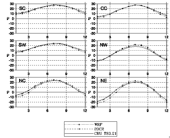 | Figure 5 Seasonal cycle of monthly the average of surface air temperature (units: ° C) for each sub-region for the period 1981-2010, from CRU TS3.21, 20CR-v2, and WRF results. |
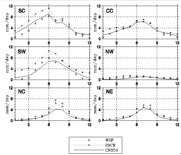 | Figure 6 Seasonal cycle of the monthly average of precipitation (units: mm d-1) for each sub-region for the period 1981-2010, from CRU TS3.21, 20CR-v2, and WRF results. |
This study performs a dynamically downscaled climatology simulation using the WRF-ARW model over East Asia, driven by 20CR-v2 lateral boundary conditions during 1900-2010. We validate the performance of the WRF model through analyzing the surface air temperature and precipitation climatology of the last 30 years in boreal winter and summer over continental China.
For surface air temperature, the WRF simulation results reproduce the main spatial patterns of CRU TS3.21 in both winter and summer. One reason for this is that WRF runs on a higher spatial resolution than 20CR-v2, meaning the regional details induced by topography can be accurately represented, e.g., the cold center over the Qilian Mountains and the warm center in the Sichuan Basin. The WRF-simulated surface air temperature biases are much reduced compared to those of 20CR-v2 in summer. However, the WRF model reproduces cold biases in most parts of China during winter.
The observational precipitation amount declines form southeast to northeast in winter and summer. The WRF simulation results reproduce the observational spatial pattern well in the two seasons. The WRF results also reproduce well the maximum precipitation in southeastern China and local precipitation over the Tianshan Mountains in winter. In summer, the WRF results capture the correct magnitude of the precipitation center along the southeastern coastal lines. Furthermore, one of the more significant improvements of the WRF-simulated summer precipitation is that the unrealistic center in Southwest China in 20CR-v2 is eliminated.
In the future, we intend to extend our analyses to the whole experimental period, and will focus on the interannual variability and the trend of surface air temperature and precipitation. Furthermore, in terms of the model’ s insufficiency, we intend to perform further experiments with different physical parameterizations in order to improve the performance of the RCM.
| 1 |
|
| 2 |
|
| 3 |
|
| 4 |
|
| 5 |
|
| 6 |
|
| 7 |
|
| 8 |
|
| 9 |
|
| 10 |
|
| 11 |
|
| 12 |
|
| 13 |
|
| 14 |
|
| 15 |
|
| 16 |
|
| 17 |
|
| 18 |
|
| 19 |
|
| 20 |
|
| 21 |
|
| 22 |
|
| 23 |
|
| 24 |
|
| 25 |
|
| 26 |
|
| 27 |
|
| 28 |
|
| 29 |
|