Land–atmosphere interactions play a crucial role in shaping Earth’s climate system, profoundly influencing weather patterns, climate variables, and ecological processes. Despite being located at similar latitude, the Tibetan Plateau (TP) and Yangtze River region (YRR) represent two distinct climate zones, garnering significant attention in this field. The former, situated in western China at an altitude exceeding 4000 m, is characterized by an arid climate, whereas the latter, located in the eastern Chinese plain, experiences a humid climate. Although both the TP and YRR have been subjects of individual research endeavors, a potential research gap exists concerning a comprehensive, direct comparison of their surface energy fluxes and other land–atmosphere interaction components.
Scientists from the Institute of Tibetan Plateau Research, China Academy of Sciences and Nanjing University used observations across various land-cover types to explore similarities and differences in land–atmosphere energy and water exchanges between the two regions. Their findings were recently published in Atmospheric and Oceanic Science Letters.
Due to its higher altitude and drier soil, the TP absorbs more solar radiation than the YRR and also reflects more radiation back. The yearly mean downward and upward shortwave radiation in the TP is 1.7 and 2.9 times that in the YRR, respectively. However, despite this difference, the net radiation between the two regions shows minimal disparity, primarily due to the greater values in longwave radiation of the YRR.
"Honestly, this phenomenon surprised us", says the corresponding author, Prof. Yaoming Ma, from the Institute of Tibetan Plateau Research, who specializes in land–atmosphere interaction over the TP. "However, the TP displays larger diurnal and seasonal variations in net radiation, with intensified heating at noon and in the warm season, but substantial cooling at night and in the cold season."
Significant variations in surface heat fluxes are evident. To facilitate comparison, the team selected the same surface types in both regions—grassland—as well as two different but typical land cover types: alpine desert for the TP and plain urban for the YRR. Surface heat fluxes were found to predominantly depend on the soil condition, with grassland in both regions exhibiting higher latent heating and lower sensible heating compared to alpine desert and urban sites.
"Soil moisture is a crucial factor affecting the distribution of energy, thereby influencing atmospheric conditions", adds Prof. Jianning Sun from Nanjing University, another corresponding author of the paper.
Overall, this study highlights the distinct characteristics of land–atmosphere interaction across various land cover types in different climatic contexts. In the future, the team hope to quantitatively explore the contributions of additional variables, such as albedo, Bowen ratio, roughness length, and soil moisture content. However, addressing the challenges of total surface heating efficiency and energy non-closure requires in-depth analysis, drawing from extensive years of observations and soil heat flux data.
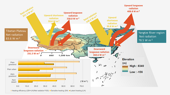
Image: Radiative components and surface heat fluxes between the Tibetan Plateau and Yangtze River region. The base map of the image is a map of China. Credited by Nan Yao.
Link:
https://doi.org/10.1016/j.aosl.2023.100447
Citation:
Nan Yao, Yaoming Ma, Binbin Wang, Jun Zou, Jianning Sun, Zhipeng Xie, 2024. A comparative study of the land–atmosphere energy and water exchanges over the Tibetan Plateau and the Yangtze River Region. Atmospheric and Oceanic Science Letters, 17(2), 100447. https://doi.org/10.1016/j.aosl.2023.100447.
|